


का विवरण Horizon Explorer AR
Point your camera at a landmark you can see on the horizon (eg. Hill, Mountain, Road, Lake, Building) and see:
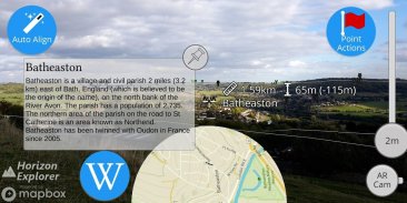
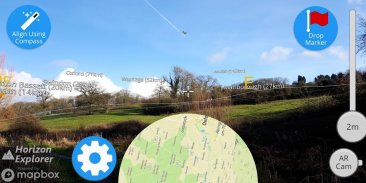
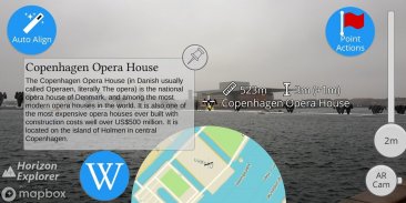
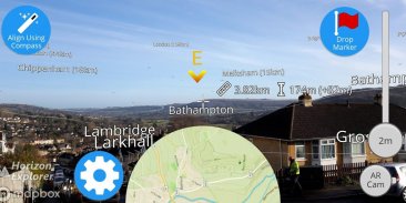
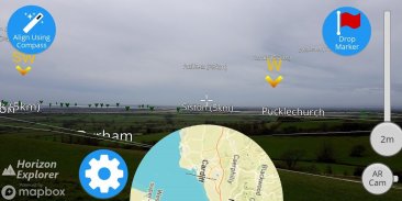
- Name of the landmark
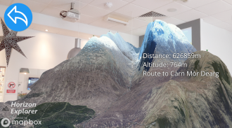
- Distance from you
- Altitude (& relative to you)
- Map of surrounding area
- Nearby towns and cities
- Wikipedia info for any landmark with a Wikipedia page
- Direction from you (eg. Northwest)
- Directions to landmark (opens in google maps)
- Street view for where you're pointing (opens in google maps)
Or use 3D Map mode:
- See terrain laid out in front of you
- Move phone to fly around the map
- Roadmap / satellite / hybrid
- Search & display 3D-maps for anywhere worldwide
- Distance, altitude and landmark names
- Infinite scroll
Horizon Explorer works worldwide, but works best on top of a hill with an unobstructed view of your surroundings. You can drag the horizon line with your finger to line up with the camera if the automatic tracking is not working very well. Or try waving your phone around in the air in a figure 8, then pressing "align using compass" to calibrate the compass.
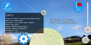
Live airplanes can also be enabled, starting from $0.99. Point at a plane and see the flight number, origin, destination, altitude and current airspeed of any commercial airline plane you can see.
If you are in a tall building, or otherwise not standing on the ground, enable "Tall Building mode" and optionally set your altitude using the slider.
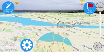
Horizon Explorer will show mountain names, lakes or forests, the names & designations of roads, and many buildings.
Wikipedia Information will be displayed for anything that has an English Wikipedia article with a location set.
This app uses Google's ARCore to do augmented reality. This technology is currently available on ~50 phones: https://developers.google.com/ar/discover/supported-devices
If you don't already have the latest ARCore app installed, you will be prompted to install / update it from the Play Store when you first open Horizon Explorer.
अपने कैमरे को एक ऐसे लैंडमार्क पर इंगित करें जिसे आप क्षितिज पर देख सकते हैं (जैसे। पहाड़ी, पर्वत, सड़क, झील, भवन) और देखें:
- लैंडमार्क का नाम
- आपसे दूरी
- ऊंचाई (और आप के सापेक्ष)
- आसपास के क्षेत्र का नक्शा
- आसपास के शहर और शहर
- विकिपीडिया पृष्ठ के साथ किसी भी लैंडमार्क के लिए विकिपीडिया जानकारी
- आप से दिशा (जैसे। उत्तर पश्चिम)
- लैंडमार्क की दिशाएँ (गूगल मैप्स में खुलती हैं)
- जहां आप इंगित कर रहे हैं, उसके लिए सड़क दृश्य (Google मानचित्र में खुलता है)
या 3D मैप मोड का उपयोग करें:
- आपके सामने बिछा हुआ इलाक़ा देखें
- नक्शे के चारों ओर उड़ान भरने के लिए फोन को हिलाएं
- रोडमैप / उपग्रह / संकर
- खोज और प्रदर्शन दुनिया भर में कहीं भी 3 डी नक्शे के लिए
- दूरी, ऊंचाई और ऐतिहासिक नाम
- अनंत सूची
होराइजन एक्सप्लोरर दुनिया भर में काम करता है, लेकिन अपने आसपास के एक अबाधित दृश्य के साथ एक पहाड़ी की चोटी पर सबसे अच्छा काम करता है। यदि आप स्वचालित ट्रैकिंग बहुत अच्छी तरह से काम नहीं कर रहे हैं तो आप अपनी उंगली से क्षितिज रेखा को कैमरे के साथ खींच सकते हैं। या एक आकृति 8 में अपने फोन को हवा में चारों ओर लहराते हुए देखें, फिर कम्पास को कैलिब्रेट करने के लिए "कंपास का उपयोग कर संरेखित करें" दबाएं।
$ 0.99 से शुरू होने वाले लाइव हवाई जहाज को भी सक्षम किया जा सकता है। एक विमान पर इंगित करें और किसी भी वाणिज्यिक एयरलाइन विमान की उड़ान संख्या, उत्पत्ति, गंतव्य, ऊंचाई और वर्तमान हवाई जहाज देखें।
यदि आप एक ऊंची इमारत में हैं, या अन्यथा जमीन पर नहीं खड़े हैं, तो "लंबा बिल्डिंग मोड" को सक्षम करें और स्लाइडर का उपयोग करके वैकल्पिक रूप से अपनी ऊंचाई निर्धारित करें।
क्षितिज एक्सप्लोरर पहाड़ के नाम, झीलों या जंगलों, सड़कों के नाम और पदनाम और कई इमारतों को दिखाएगा।
विकिपीडिया सूचना किसी भी चीज़ के लिए प्रदर्शित होगी जिसमें एक स्थान सेट के साथ एक अंग्रेज़ी विकिपीडिया लेख है।
यह ऐप संवर्धित वास्तविकता को करने के लिए Google के ARCore का उपयोग करता है। यह तकनीक वर्तमान में ~ 50 फोनों पर उपलब्ध है: https://developers.google.com/ar/discover/supported-devices
यदि आपके पास पहले से नवीनतम ARCore ऐप इंस्टॉल नहीं है, तो आपको Play स्टोर से इसे अपडेट करने / अपडेट करने के लिए प्रेरित किया जाएगा जब आप पहली बार रिज़ेरियन ओपन करेंगे।
Horizon Explorer AR - Version 1.23.0
(23-04-2020)Horizon Explorer AR - एपीके जानकारी
एपीके संस्करण: 1.23.0पैकेज: com.arrowsd.horizonexplorerApps in the same category
You may also like...


